
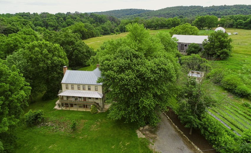
We continue our series on the Farmsteads of Antietam with the first farm located off of the park which is the Henry Rohrbach Farm. One of the largest farms in the area at the time of the Battle of Antietam, this farm sits just north of the Lower Bridge off the Burnside Bridge Road. It cannot be seen from the road and is private property, so please do NOT go up onto the property without permission.

Passenger ship like the Phoenix
The Rohrbach family line goes back to Zweibrucken in the Palatinate region of Germany. Peter Rohrbach was born between 1720 and 1730. In 1754 Peter, most likely a farmer arrived in Philadelphia aboard the ship Phoenix. The spelling of the last name included “Rorabaugh”, Rohrbacher”, Roarabaugh”, or “Rohrback”. It is believed that Peter had seven children and they belonged to the Reformed Church.
One of Peter’s children, John, or Johannes, Rohrbach, was born in 1757 near Philadelphia. In 1778, John married Catherine Kinead from New York. They resided in Bucks County until 1782, when they moved to Washington County, Maryland with their first born son, John, Jr.
It is not known where the Rohrbach’s lived once they arrived in Sharpsburg, but it’s possible that they rented property near the Antietam Creek from John Smith. Here John and Catherine would have three more sons; Henry, William and Jacob, all born two years apart. In 1807, John Rohrbach had passed away. That same year John and Mary Smith sold fourteen acres of Jacob’s Ladder to John Rohrbach, Jr.. This is the first recorded land acquisition in Washington County involving the Rohrbach family.

Militia Muster Roll Captain Miller’s men 1813
During the War of 1812, militia units were called upon from the area to defend Washington and Baltimore. In 1813, Captain John Miller recruited a company of militia. Of the 73 men organized from the Sharpsburg area, William Rohrbach served as 1st Lieutenant and Jacob Rohrbach was the Ensign in the company. By 1812, their brother, Henry and his wife just had their fifth and sixth child, so it’s very possible this is the reason he did not join up with the militia.
Henry B. Rohrbach was the first child of John Rohrbach to be born in Washington County in 1783. Henry would marry Barbara Barks on January 22, 1806 and before the end of the year, the first of their thirteen children were born. Their first born son was named in honor of Henry’s father, John. The large Rohrbach family included: Elizabeth (1807), Mary (1809), Catherine (1810), twin sons – Henry Jr. and Jacob (1812), Daniel (1815), Barbara (1817), Caroline (1819), Elias (1820), Noah (1822), Ann (1824) and Cornelius (1827).
As the family grew in size so did the Rohrbach land holdings. Starting in 1818, Henry purchased 24 acres of Jacob’s Ladder. During this time the Rohrbach farm was built into a thriving farmstead on the hill overlooking the Antietam. A root cellar, springhouse and kitchen surrounded the two-story brick house. Unlike his neighbors, Henry built a large brick-end bank barn just a little further up the hill. To add to the uniqueness of his barn, a decorative pattern of open ventilators were added along with his initials “H’ “R” high on the gable peak. A number of other domestic and agricultural outbuildings completed the complex with a farm road leading down to the Maple Swamp Road along the Antietam Creek.

Henry Rohrbach house cir. 1920

Henry Rohrbach barn cir. 1920

H R and decorative brickwork on barn

Spring house

Smokehouse

Outbuilding

Rohrback Bridge, cir 1862
In 1833, the Washington County Commissioners contracted John Weaver to select a location to construct a bridge over the Antietam Creek on the Sharpsburg and Maple Swamp Road. This road traversed along the Town Run past the Rohrbach’s neighbors’, the Sherrick and the Otto families, to the Antietam. Weaver selected a site near the Rohrbach property line, most likely due to the fact that limestone could be quarried off the hillside. The bridge was completed by 1836 for a cost of $2,300. The Maple Swamp Road would become the Sharpsburg – Rohrersville Road and the bridge was named the Rohrbach Bridge.
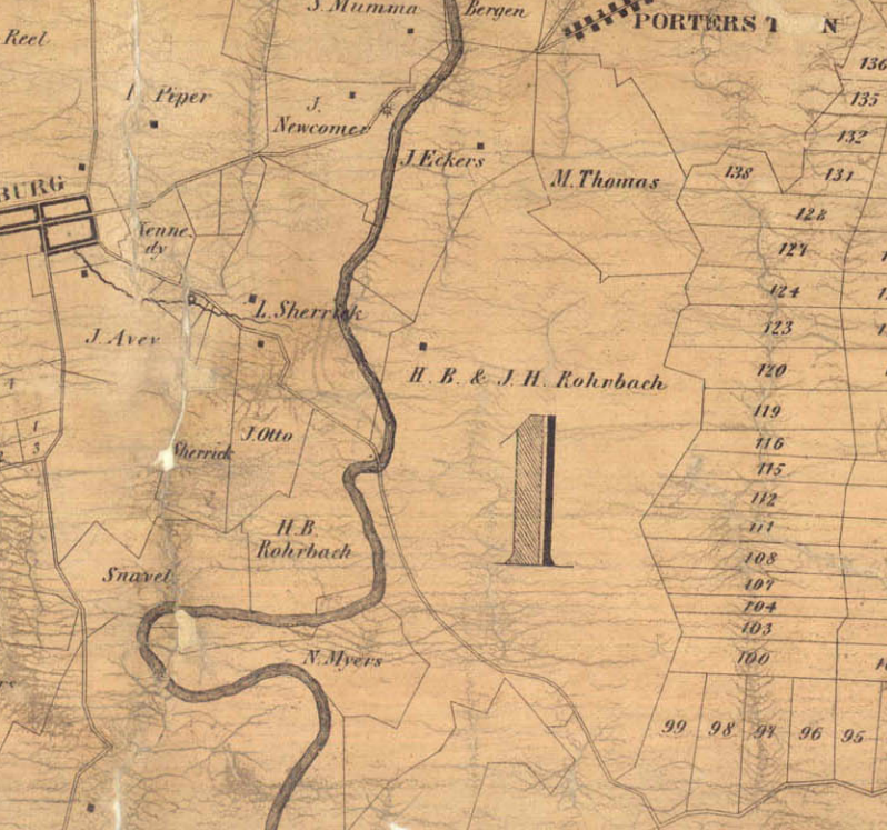
1859 Taggert Map showing the large Rohrbach estate
Just before his death in 1851, Henry had acquired well over 500 acres stretching on both sides of the Antietam Creek. The 1859 Taggert map shows how extensive this was. The property stretched from the Antietam Creek to the west hillside of Elk Ridge. After the death of their father, it appears that the property was divided among the Rohrbach children. But according to land records, Henry Jr. and his twin brother Jacob Rohrbach would acquire most of that property back from their siblings and spouses.
Noah Rohrbach Farm
In 1855, it appears that a portion of this land holdings, approximately 140 acres, was conveyed to Henry’s younger brothers, Noah and Elias Rohrbach. The Noah Rohrbach farm to the east of the Antietam Creek and along the road dates to this period as does the farm to the east of the Rohrbach farm along what is today Churchy Road. According to the Carman-Cope maps, Jacob F. Miller lived at this property in 1862. More research will have to be done to determine if this was another Rohrbach dwelling before the war and when it was acquired by Jacob Miller.
In 1835, Henry B. Rohrbach, Jr courted Martha Ann Piper, the daughter of Henry and Elizabeth Piper. The Pipers lived on a large farm just north of Sharpsburg. They were married in 1836 and the following year they had their one and only child, Mary Jane. They most likely lived in a small house on the family farm as the 1850 census indicates the other brothers were still living with their parents, but Henry Jr. and Martha are the next dwelling entry. There is no record of Henry’s brother Jacob being married so Jacob continued to live and work on the family farm which was known as Walton’s Grove.

Approximate boundary of the Rohrbach farms in 1862.

Henry Rohrbach farm layout in 1862
By 1860, Henry and Jacob Rohrbach owned 275 improved acres and 100 unimproved acres. Walton’s Grove was a prosperous and diversified farm. The Rohrbach farm was valued at $17,000 with a value of $1,500 in livestock. “The farm produced 1700 bushels of wheat, 100 bushels of rye, 1200 bushels of Indian corn, 40 bushels of oats, 150 pounds of wool, 50 bushels of potatoes, 15 bushels of sweet potatoes, $50 of orchard products, 900 pounds of butter, 40 tons of hay, 12 bushels of clover seed, and 80 pounds of honey”. As compared to the neighboring farms, it appeared the Rohrbach’s were moving away from grain production and focusing on dairy operations and other forms of crops like sweet potatoes and honey production.

1860 Census shows both the Rohrbach families.
In 1862, Walton’s Grove was not only home to Henry, Martha and Jacob Rohrbach, but Mary Jane’s family as well. She had married Henry C. Mumma, whose parents, Samuel and Elizabeth Mumma, lived near the Dunker Church and the Hog Trough Lane. Mary Jane and Henry had a little girl named Martha Ada, who went by just Ada. Mary Jane was also pregnant and expecting in the fall.
Like the rest of the farmers around the Sharpsburg area in the late summer early fall of 1862, their store rooms were filled, cellars were stocked and most of the crops were in with the exception of a 20-acre cornfield. On September 15, the Rohrbach’s “received word from their neighbors, John Otto and Joseph Sherrick that the Confederates were occupying the west bank of the Antietam Creek and that the soldiers were helping themselves to everything they could lay their hands on: eggs, bread, jam, etc. Henry should take some precautions”. The next day, the Union Ninth Corps moved onto the Rohrbach farm. Union artillery took up positions on the high ground, the infantry made camp on the east of the hills in the fields and soon the fence rails began to disappear for their fires.
At day break on September 17, the battle began. According to young Ada, “the noise of the battle was plainly heard, the popping of the guns, the rattling of the sabers , and the roaring of the cannon”. She recalls seeing General Ambrose Burnside riding up to their house and telling her grandparents to leave, stating, “your buildings will all be destroyed as you are directly in the line of fire”. The Rohrbach family minus Henry and Jacob left in a carriage to the safety of a neighbor, possibly the Geeting farm, which would soon become a hospital as well.

Carman-Cope Battlefield map of the Rohrbach farm
The Rohrbach farm had become the headquarters for the Union Ninth Corps and a staging area for infantry who began marching across the farm to get into position to assault the bridge. Around 10 a.m. the first failed attack began and Union casualties were coming back to the farm, this included Colonel Henry Kingsbury who led the 11th Connecticut. Finally, after two more attempts the Union had taken the bridge by 1pm and the division of General Isaac Rodman had forded the Antietam Creek down at Snavely’s Ford.
The Ninth Corps quickly moved to the other side of the creek to get into position to begin their advance toward Sharpsburg. Around 3:00 p.m., the Union soldiers moved across the Otto and Sherrick farmsteads. But just as their advance had reached the hill overlooking the town of Sharpsburg, the Union right flank was hit by one more Confederate counterattack – Gen. A.P. Hill’s Confederate division arrived from Harpers Ferry. As it happened, General Rodman was struck by gunfire from the attack and taken to the Rohrbach farm. Throughout the afternoon and into the evening, Ninth Corps wounded were taken back to the Rohrbach farm, to the Jacob F. Miller farm, to Chrystal Springs and others hospitals in Keedysville.
According to Ada, when her grandmother Martha Rohrbach returned to the farm she “rejoiced to see all the buildings standing, but the front porch was occupied with the doctors who were amputating, and the house filled with wounded and dying soldiers. Grandfather was busy helping the doctors, in every way he could… Grandmother told me she went to the rear of the house but all around the porch and yard the dead soldiers lay so think she could not reach the porch”. Like Henry, Martha Rohrbach did what she could to help the wounded; baking bread and providing water for the soldiers.

Col. Henry Kingsbury, 11th CT Vol. Inf.

Gen. Isaac Rodman
3rd Division of the IX Corps
Later that evening a tearful General Burnside came to the house to visit Colonel Kingsbury and sat on the couch next to him. Kingsbury lingered on throughout the night but died of his wounds on the 18th. General Rodman’s wife Sally came from Peace Dale, Rhode Island to be at his side, but he too would succumb to his wounds 12 days later at the Rohrbach house.

H.B. Rohrbach received $504 according to the Herald and Torch Light. March 12, 1891
The Rohrbach farm buildings had suffered only minor damage, but Henry filed a claim with the Federal Government for the use of his house, two barns, and outbuildings as hospitals for five days. According to an agent of the Army Quartermaster Department that testified in support of Rohrbach’s claims, “the corn, wheat and hay were fed to the horses of General Burnside’s command at a time when it seems forage could not readily be procured from regular services… After the battle a portion of Major General Burnside’s command occupied claimants farm, using house and barns, and consuming forage on the farm.” The Rohrbach’s losses had totaled $3,097.80 and included three milk cows, one large bull, 400 bushels of apples and two gallons of old grape wine for the wounded. There is very little evidence that he ever received any compensation before his death in 1890. According to a newspaper article in March, 1891, Jacob E. Thomas, executor of the estate received $504. Like his brother, Noah Rohrbach’s farm was used as a hospital as well. However, of the $907.95 claim that Noah submitted in 1873, he received $339.60.
Although there were no civilian casualties during the battle, many Sharpsburg residents died soon after the fighting due to all the death and disease around their once peaceful home. The Rohrbach’s daughter, Mary Jane Mumma then 25, had “taken ill and died in November and a daughter who was born a few days before her death, also passed away”.
As a result of the decimation of their farm, the Rohrbach farm was divided the following year. Part of it was conveyed to Noah and part was sold to Henry Mumma. Henry and Martha Ann Rohrbach purchased a home in Sharpsburg. Henry’s brother Jacob and their grand-daughter Ada, would also move in with them in Sharpsburg
On July 4, 1864 during Jubal Early’s third invasion into the North, Confederate soldiers, believed to be Mosby’s Rangers, stopped at the Rohrbach house in Sharpsburg looking for horses in the middle of the night. A confrontation occurred between the raiders and Henry’s brother Jacob and he was shot and killed in his bedroom.

Parlor throw made by Martha Ada Thomas, 1880 – 1890. Donated to the Smithsonian
The Rohrbach’s continued to live on Main Street in Sharpsburg after the war. In 1879 the wedding of Ada and Jacob E. Thomas was held at the Rohrbach house. Although Ada and her husband moved to Baltimore to raise a family, Ada continued to return to visit her grandparents. Henry died in 1890 and Martha passed away in 1904 at the age of 87. They are buried together at the Mountain View Cemetery in Sharpsburg. The house remained in the Rohrbach family until Ada passed away in 1943. The Rohrbach house would be turned into a bed and breakfast in the late 1980’s and eventually named in honor of Jacob Rohrbach.

Gravesite of the Henry and Martha Rohrbach at the Mountain View Cemetery
Soon after the battle the Rohrbach Bridge was renamed the Burnside Bridge. Over the years, parcels of the Rohrbach farm were sold off. On the west side of the Antietam, the National Park Service would eventually acquire that portion of the Rohrbach farm from the Washington County Historical Society in 1940. On the east side of the creek the NPS owns a 24-acre parcel near the bend in the creek, locally known as Molly’s Hole. The rest of the once large Rohrbach farmstead is all private property today but the Henry Rohrbach and the Noah Rohrbach farms remain an eyewitness to the history of the Battle of Antietam.

Henry Rohrbach house

Noah Rohrbach house
Sources:
-
Ancestry.com, Henry Rohrbach Family, Census Data 1850-1890. Retrieved from: https://www.ancestry.com\
-
Biscoe, Thomas Dwight and Walt Stanley. The view from the Conf. side of Antietam Creek near Burnside Bridge looks probably about North,. DeGolyer Library, Southern Methodist University, 1884. Retrieved from: http://digitalcollections.smu.edu/cdm/singleitem/collection/civ/id/132/rec/25
-
Damman, Gordon and John W. Schildt. Hospitals in the Maryland Campaign, 1862,. E. Graphics, Brunswick, MD, 2019
-
Ernst, Kathleen A., Too Afraid to Cry: Maryland Civilians in the Antietam Campaign, Mechanicsburg, PA: Stackpole Books, 1999.
-
Find a Grave Website. Rohrbach Family, Isaac Rodman. Retrieved from https://www.findagrave.com/memorial/5896745/isaac-peace-rodman
-
Lauver, Fred. Lauver and Davis Family Trees, John Rohrbach Retrived from http://www.timevoyagers.com/lauver01/d62.htm
-
Library of Congress Prints and Photographs Division; Historic American Buildings Survey/Historic American Engineering Record/Historic American Landscapes Survey, Antietam, Maryland. Battlefield near Sherrick’s house where the 79th N.Y. Vols. fought after they crossed the creek. Group of dead Confederates, MD. Washington, D.C. Retrieved from https://www.loc.gov/resource/cwpb.01112/
-
Maryland Historical Trust, Henry Rohrbach Farm, WA-II-330, Maryland Inventory of Historic Properties Form, 1976.. Noah Rohrbach House, WA-II-363, Maryland Inventory of Historic Properties Form, 1994
-
Nelson, John N. “As Grain Fall Before the Reaper”, The Federal Hospital Sites and Identified Federal Casualties at Antietam. Hagerstown, MD. 2004
-
Reardon, Carol and Tom Vossler, A Field Guide to Antietam: experiencing the battlefield through history, places and people, Chapel Hill: The University of North Carolina Press, 2016.
-
Smithsonian Institution, National Museum of American History 1880 – 1890 Martha Thomas’s “Fan” Parlor Throw. Retrieved from https://womenshistory.si.edu/object/1880-1890-martha-thomass-fan-parlor-throw:nmah_556411
-
Taggert, Thomas, Map of Washington County. L. McKee and C.G. Roberton, Hagerstown, Maryland 1859.
-
U.S. National Park Service, Burnside Bridge Area Cultural Landscape Inventory, Antietam National Battlefield, Washington D.C.: Government Printing Office, 2016.
-
U.S. National Park Service, Burnside Bridge Area Cultural Landscape Report, Antietam National Battlefield, Washington D.C.: Government Printing Office, 2018.
-
Walker, Kevin M., Antietam Farmsteads: A Guide to the Battlefield Landscape. Sharpsburg: Western Maryland Interpretive Association, 2010.
-
Western Maryland’s Historical Library. Photographs Sharpsburg, Henry Rohrback Farm, aka Walton/ Walnut Grove Farm, photo circa 1920 from the Marcia Swain collection Retrieved from https://digital.whilbr.org/digital/collection/p16715coll42/id/16/
-
U.S. War Department, Atlas of the battlefield of Antietam, prepared under the direction of the Antietam Battlefield Board, lieut. col. Geo. W. Davis, U.S.A., president, gen. E.A. Carman, U.S.V., gen. H Heth, C.S.A. Surveyed by lieut. col. E.B. Cope, engineer, H.W. Mattern, assistant engineer, of the Gettysburg National Park. Drawn by Charles H. Ourand, 1899. Position of troops by gen. E. A. Carman. Published by authority of the Secretary of War, under the direction of the Chief of Engineers, U.S. Army, 1908.” Washington, Government Printing Office, 1908. Retrieved from https://www.loc.gov/resource/g3842am.gcw0248000/?sp=5.
Leave A Comment