
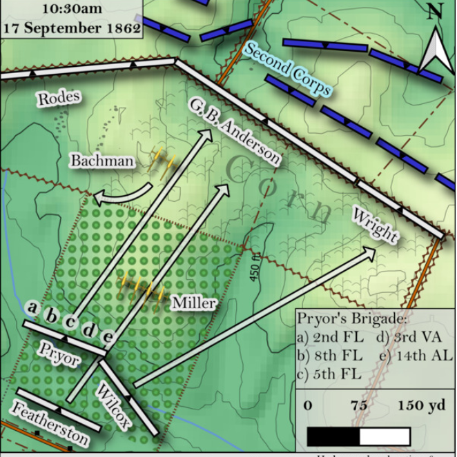
Example of Aaron’s map
Join us on Wednesday, August 3 for Aaron’s presentation. “Mapping the Antietam Battlefield in the 21st Century – the Cope Maps Revisited” builds upon the legacy of the Antietam Battlefield Board Cope Maps and presents an innovative analysis of the terrain at Antietam. Aaron will explain how modern mapping technology is aiding the scholar in answering age-old questions about the ebb and flow of the Battle of Antietam. The presentation will highlight how historic maps may be transformed from flat pieces of paper to three-dimensional physical terrain pieces and how modern geospatial analysis can unearth answers to unknowns about the Battle of Antietam.

Aaron Holley
Aaron Holley is a native of West Virginia and a lifetime student of the American Civil War. He currently resides in Hardy County, West Virginia with his wife and daughter. Aaron holds a Bachelor of Science in Forestry and a Master of Science in Forestry from West Virginia University and has experience working on forest conservation projects worldwide. This professional experience has led Aaron to be intimately familiar with the practice of cartography and modern mapping techniques, which when paired with his passion for the American Civil War, results in the information in this presentation: “Mapping the Antietam Battlefield in the 21st Century – the Cope Maps Revisited”.
Come join leading historians and Antietam Battlefield Guides as they discuss intriguing topics of the Maryland Campaign of 1862 and the Civil War during our Civil War Summer Lecture Series.
These outdoors programs will be held at the Jacob Rohrbach Inn on Wednesday evenings at 7:00 p.m. These outdoor programs are free and open to the public. To ensure adequate seating, please bring a chair. In case of inclement weather, lectures will be held at the Sharpsburg Christ Reformed UCC Church at 117 Main Street. For updates and changes to the schedule check our Facebook page.
Leave A Comment